| View previous topic :: View next topic |
| Author |
Message |
Mariano Tomatis
Joined: 17 Jun 2004
Posts: 2475
Location: Torino
|
 Posted: 1 July 2007, 12:03 am Post subject: Geometries Strange Loop Posted: 1 July 2007, 12:03 am Post subject: Geometries Strange Loop |
|
|
In order to put some pepper into the discussion, I quote a post I sent in another RLC related forum in English.
I was criticizing the crazy geometries suggested on maps around RLC, Perillos, Oak Island and so on. In these occasions, I always think about the "strange loop" of precision.
A: Look!!! That map/painting/gravure fits PERFECTLY my geometry!!!
B: Well, but considering ... this and that ... you can see that it is not precise as you say.
A: What do you expect from ancient people? They couldn't be too much precise... they were ancients...
In other words, ancients were more or less precise: both arguments are good for geometry-lovers! Head I win, tail too... 
_________________
Mariano Tomatis Antoniono |
|
| Back to top |
|
 |
Markus
Joined: 28 Jun 2007
Posts: 30
Location: Frankfurt am Main, Germany
|
| Posted: 1 July 2007, 8:15 am Post subject: |
|
|
Another good reason to say good-bye to pseudo geometric drawings on maps.  
I would suggest to differenciate between paintings and maps. Even for the "ancient" people it was easy to hide a perfect geometry in a painting. And they did. Not necessarily to hide secrets.
But it was not possible (and I doubt if it would be today) to "draw" anything exact on a map by erecting churches and castles in a distance of some kilometres. |
|
| Back to top |
|
|
Markus
Joined: 28 Jun 2007
Posts: 30
Location: Frankfurt am Main, Germany
|
| Posted: 1 July 2007, 12:38 pm Post subject: |
|
|
Yes, the ancients were not that precise. Louis Charpentier had to "help" a little. This comes out, when one compares the geografic position of the related cities and the stars of the vierge
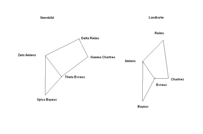
I painted these diagramms last year from reliable sources. Charpentiers theorie is a fake. A lot has been written on Charpentiers "theory" since that book...  |
|
| Back to top |
|
|
Mariano Tomatis
Joined: 17 Jun 2004
Posts: 2475
Location: Torino
|
|
| Back to top |
|
|
Markus
Joined: 28 Jun 2007
Posts: 30
Location: Frankfurt am Main, Germany
|
| Posted: 2 July 2007, 9:45 pm Post subject: |
|
|
Yes, Mariano, if I ever had any doubts, now - after Andrew Goughs contribution - I am absolutely convinced  There must be something strange with geometry. There must be something strange with geometry.
The one and only question remains: cui bono?  (=who cares?) (=who cares?) |
|
| Back to top |
|
|
Markus
Joined: 28 Jun 2007
Posts: 30
Location: Frankfurt am Main, Germany
|
| Posted: 4 July 2007, 5:58 pm Post subject: |
|
|
My opinion to manmade geometry in the landscape:
It was almost impossible to set any significant geometric structure on greater distances.
As long as man could erect visible points fram A to B, no prob. The problem starts, when you want to "paint" polygons on the landscape covering 20 km diameter. To do this, you would need somewhat as an exact eternal map. There are no exact eternal maps and probably never will be, as any map contains compromises and is distorted to a certain amount. This, because you can not project a ball-shaped surface on an two-dimensional plan without compromises.
The maps we all had in school have a grid-system, which seemed to be exact, or lets say, we where used to it. Mankind was able to produce almost accurate maps only since we had satellites. So our grid system results from the scientific conventions in the sixties.
These grids are about to be given up, since the gps standard required a new grid system on a new conventional basis. On a map showing less than 100 Km on a Din A 4 page the difference makes already some millimeters.
In Reality, this slight difference would force the treasure hunter to dig a ditch of some hundred meters in the "center of the fantastic triangle of the templars"! Such a difference in only the last fifty years because of another convention.
hmmm.
One would say, our ancestors could have been powered by persian, egyptian, arabic or chinese navigators(=nautonniers) might have had a secret knowledge, which was inherited and brought to us by the templars.
I dont think so. Without satellites? I say: no.
Mankind has been able to trace the degrees of a latitude rather early. This, because you can "see" the latitude on a very simply instrument only by watching the north star. On sea. Rather exact.
The problem of longitudes has not been solved not earlier than in the eighteen century. The maps of the elisabethian era very quite helpful (on seas), but not exact enough to allow painting Lincolns monsters on Land.
Sorry, Henry. I dont believe in Templar Pentagons on a map. |
|
| Back to top |
|
|
Mariano Tomatis
Joined: 17 Jun 2004
Posts: 2475
Location: Torino
|
|
| Back to top |
|
|
|

 Search
